


Most A&E firms don’t struggle with the definition of site analysis. They struggle with the inconsistency of how it’s done.
And that inconsistency can lead to missed details, shaky assumptions, and downstream surprises that cost hours and margin.
Site analysis is the study of a location’s physical, environmental, cultural, and legal conditions. Those are the basics. But what matters more is how the findings from this phase shape the rest of the project. When the process varies from one PM or designer to another, critical insights get lost.
That’s when problems show up later: constraints that weren’t caught early, unclear expectations, extra coordination, and rework that should never have happened.
This guide reframes site analysis at the firm level and shows you how to turn early findings into reliable, actionable inputs using a standardized workflow purpose-built for A&E firms.
What Site Analysis Really Means at the Firm Level
Site analysis is the examination of a site’s physical, environmental, legal, and contextual conditions.
In practical terms, it's a data collection exercise, with firms focused on collecting two types of data during site analysis:
- Hard data: Topography, zoning, soil conditions, utilities, and surveys
- Soft data: Views, noise levels, circulation patterns, and neighborhood context
But site analysis is about much more than just gathering information.
Site findings inform feasibility assumptions, early design parameters, and initial risk assessments. They help principals set accurate scope and fees, and allow PMs to set and enforce scope boundaries, protecting against creep during feasibility and pre-design phases.
For instance, an architecture firm that identifies a high water table during early site analysis can subsequently adjust foundation plans and stormwater strategies before schematic design, avoiding redesign and cost escalation.
When the way this information is gathered, documented, and interpreted varies from one project team to another, site analysis ceases to be a reliable planning input and becomes a source of hidden risk.
Two teams can analyze the same site and walk away with different assumptions about constraints, scope, and engineering effort. That variability is what leads to redesign, fee erosion, and unplanned consultant involvement later in the project.
When done consistently across the firm, strong site analysis translates directly into profit protection.
The Impact of Site Analysis On Project Success and Firm Profitability

Site analysis doesn’t just give A&E firms the information they need to proceed with design. It informs decisions around project feasibility, feeds budget creation, and fuels team alignment.
When site analysis is performed consistently across the firm, these benefits emerge.
Shaping feasibility decisions
Site analysis provides architects with visibility into constraints that can impact foundations, drainage, access, utilities, and more.
This data can guide early design direction and scope boundaries.
For example, early site analysis may reveal that service vehicle access is constrained by narrow streets and limited turning radii. Identifying this during feasibility allows the architect to adjust building placement and loading zones, while the PM factors additional coordination time and potential civil or traffic consultant involvement into the scope and fee.
It’s not just about internal decision-making, though. Firms gain an opportunity to strengthen client communication by clearly explaining limitations before the design effort accelerates.
Influencing budgets
Findings from site analyses influence budgeting, fee modelling, and resource planning before hard commitments are made.
Understanding initial site conditions helps PMs make core decisions around staffing, required consultants, and the level of engineering involvement needed.
For instance, if site analysis identifies complex zoning overlays and multiple easements affecting the buildable area, the PM can budget additional planning analysis, coordination time, and legal review upfront. That early adjustment informs fee modeling, staffing allocations, and consultant engagement before commitments are locked in.
This has an outsized downstream impact on financial health and project profitability by protecting against uncontrolled scope growth, rework, and change orders caused by unidentified constraints.
Helping teams stay aligned
Accurate site data uncovered early on helps align teams and prevents miscommunication between architects, PMs, civil partners, and surveyors.
For instance, early hydrology, topography, and flood-risk analysis performed during site analysis for the Buffalo Bayou Park redevelopment in Houston led to a landscape that could absorb and redirect stormwater rather than fail under it.
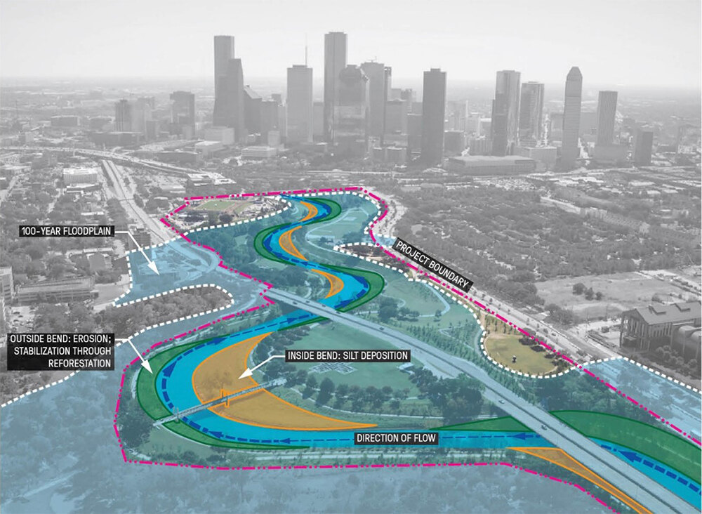
As a result, the park avoided an estimated $2 million in damage from Hurricane Harvey.
The Critical Elements to Assess, And Why Firms Commonly Miss Them
Each of the seven elements discussed below comes with practical implications that influence feasibility, design direction, engineering requirements, and scope boundaries.
We’ll explore common risks and failure points, and what PMs should verify to support accurate proposals and present scope changes and redesigns down the track.
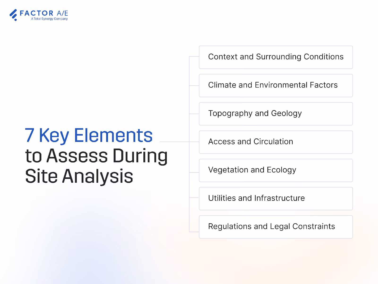
Context and Surrounding Conditions
The project architect assesses adjacent buildings, heights, uses, architectural patterns, street character, and community activity.
This shapes early discussions on neighborhood expectations and potential objections, and guides:
- Massing
- Setbacks
- Privacy
- Solar access
- How new works fit with the surrounding fabric
The biggest failure point here is when surrounding conditions are reviewed visually but not thoroughly documented, leading to misalignment during concept development and redesign efforts when community feedback contradicts assumptions.
Here, PMs should verify height restrictions, overshadowing risks, sensitive adjacencies, and any planning overlays that will restrict design options.
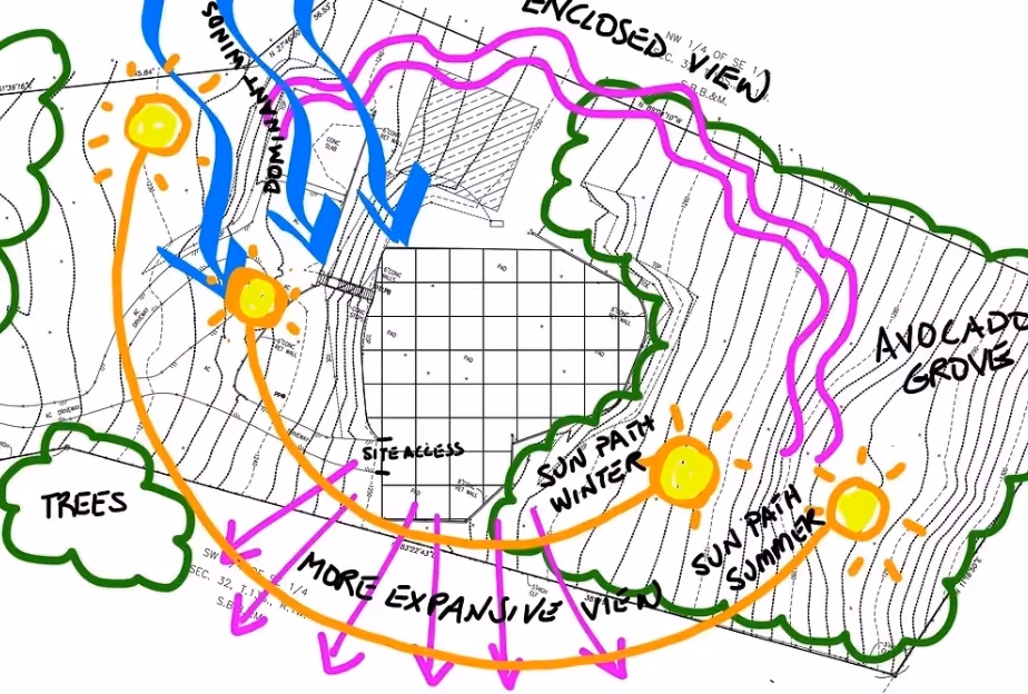
Climate and Environmental Factors
Teams should not only be concerned with how the project may impact the surrounding environment, but also with how the environment impacts project viability.
Factors like sun paths, prevailing winds, temperature swings, humidity, seasonal behavior, and microclimate conditions inform:
- Building orientation
- Window placement
- Energy strategy
- Comfort outcomes
- Long-term operational costs
This stage is often overlooked in environmental analysis, leading to costly design corrections when revisited too late.
PMs should verify solar impact on key elevations, prevailing wind direction, shading needs, and any microclimate anomalies affecting design or energy performance.
Topography and Geology
Topography and geology directly influence foundations, retaining walls, stormwater strategy, accessibility, and construction complexity. Poor soils or steep slopes especially have a material impact on both scope and budget.
When teams progress without on-site verification, incorrect grading assumptions are often embedded in designs, leading to major rework when civil engineering discovers soil or drainage conditions that contradict early design decisions.
PMs must verify:
- Soil reports
- Existing drainage paths
- Slope constraints
- Retaining requirements
- Water table impacts on foundations
Access and Circulation
To understand how real people will access a finished project, architects assess current:
- Pedestrian paths
- Vehicle routes
- Service access
- Parking
- Emergency access
- Transit proximity
This is another spot where teams often rely solely on client input rather than verifying traffic and access assumptions with on-site observations, leading to delays and redesigns when fire, delivery, or parking requirements invalidate early site layouts.
PMs should verify fire access compliance, truck turning paths, service entries, and the adequacy of existing roadway infrastructure.
Vegetation and Ecology
Vegetation (from existing trees to shade patterns and existing habitats) influences grading, drainage, structural decisions, environmental approvals, and long-term landscape costs.

A common failure point here is inaccurate mapping of tree locations and root zones, which creates conflicts with placement and pushes up project costs and budgets when structural or grading solutions must adapt to protected vegetation.
PMs must verify:
- Protected species requirements
- Realistic tree retention feasibility
- Canopy impacts on daylighting
- Root zone conflicts with proposed structures
Utilities and Infrastructure
Architects must assess and document water, sewer, stormwater, electrical, gas, telecom, and fire services above and below ground.
Utility conflicts often arise when teams rely on outdated utility plans or client-provided PDFs and fail to verify on-site, resulting in major redesigns, change orders, and construction delays.
At this stage, PMs should verify:
- Connection capacity
- Accurate utility locations
- Easement boundaries
- Any upgrades required for service loads
Regulations and Legal Constraints
To understand what is permissible on the site, teams should assess:
- Zoning rules
- Height limits
- Overlays
- Conservation areas
- Easements
- Covenants
- Buildable-area restrictions
The biggest problem here is when teams skim zoning summaries but don’t map setbacks, overlays, or easements in detail. This creates unbillable redesign work when concepts violate zoning, heritage, or conservation requirements.
PMs should double-check verified zoning classifications, mapped easements, heritage constraints, setback envelopes, and any legal restrictions that alter buildable area.
A Standardized Site Analysis Workflow for A&E Firms

When PMs or designers approach site analysis differently, it creates inconsistency, unclear ownership, documentation gaps, and downstream risk.
Use this firmwide, step-by-step workflow to conduct a thorough, standardized site analysis from desktop research to synthesis and early project planning.
1. Desktop Research and Preparation
Begin by gathering all existing documentation, such as:
- Zoning maps
- Surveys
- Utility plans
- GIS layers
- Soil reports
- Flood records
- Historical imagery
Use this data to identify constraints that require on-site verification and any assumptions that influence early feasibility. These indicators inform staffing plans, level-of-effort estimates, and required consultant involvement.
For instance, a firm conducting a desktop study before visiting a proposed site by identifying outdated utility information. By verifying this on-site and documenting it in the synthesis report, the PM can adjust scope and engage consultants early, preventing downstream interruptions.
This stage should be led by the project architect, with PM oversight, to ensure findings align with the scope and fee assumptions.
2. On-Site Observation and Verification
In the field, begin with a full site-walk to confirm or correct desktop assumptions.
Assess traffic patterns, terrain, drainage, noise, and access, and verify utilities. Missing documentation on these site features commonly leads to scope creep and underpricing of engineering effort.
Capture sketches and panoramic photos to add visual context to analysis documentation, and use drones where applicable to document topography and hard-to-reach areas.
3. Organize and Document Site Data
Strong site analysis isn’t just about collecting data; it’s about organizing and presenting it effectively for later planning and design work.
Consolidate all photos, notes, measurements, and observations into a structured data set. Diagrams, maps, and layered visuals are all great ways to translate raw site data into useful information.
Categorization and standardization are important to ease of understanding.
Define and enforce folder structure and naming conventions so all teams use a single source of truth, and categorize findings into standard buckets such as:
- Access
- Climate
- Vegetation
- Legal constraints
- Utilities
Project managers should verify completeness, accuracy, and alignment with firm standards before modeling begins.
4. Digital Modeling and Environmental Analysis
Back at the desk, import surveys and measurements into CAD or BIM to build terrain models, and run simulations for:
- Sun
- Wind
- Shading
- Hydrology
- Seasonal behavior
Recent research shows that when teams pair detailed site and project data with modern modelling tools, they significantly improve early forecasting and reduce downstream surprises.
In a mid-rise case study in Texas, a 4D/5D digital-twin workflow reduced labor-estimation effort by 43% and cut overtime hours by 6%, largely because teams had accurate site and progress data feeding into the model.
At this point, PMs should verify that model assumptions match verified site conditions and that risks are incorporated into planning and staffing.
5. Synthesize Findings Into Actionable Design Inputs
Translate the raw data and interpretations from the previous steps into early design guidance, such as buildable areas and orientation recommendations. Present opportunities for favorable views or passive solar benefits.
Summarize implications for scope boundaries, consultant budgets, and staffing allocations, which will allow PMs to:
- Forecast hours accurately
- Set reasonable client expectations
- Prevent mid-phase overruns
- Determine which constraints require specialist input
6. Review With Stakeholders and Update Project Planning
Finally, share key findings with owners, PMs, engineers, and consultants.
These stakeholders may need to adjust scope, schedule, staffing, and consultant budgets based on documented constraints and determine where further engineering studies or specialist inputs are required.
For instance, a PM reviewing early site findings might discover that utility connection points were farther from the buildable area than expected.
Because this was documented early, the PM can increase coordination hours, adjust the engineering budget, and bring in the civil consultant sooner. The client understands the change because the constraint was shown visually, and the project avoids a mid-phase fee overrun.
Track decisions in a centralized record to preserve the rationale behind constraints, assumptions, and scope boundaries.

Avoiding the Top Failure Points in Early-Phase Site Work
Most common breakdowns in early-phase site work are avoidable with proper practice.
We’ll explore the operational practices firms can adopt to prevent early-phase mistakes and keep projects aligned with scope, staffing, and budget expectations.
Early-phase scope creep
Concept work regularly expands because site findings are incomplete or undocumented.
The best solution is to use a standardized scope checklist tied to deliverables and responsibilities so PMs can enforce boundaries early.
Missed constraints due to scattered data
When zoning, utilities, surveys, and GIS files are stored across emails or PDFs, teams often overlook constraints.
A&E firms can mitigate this risk by centralizing all site data in a single, structured folder with consistent naming conventions across the firm.
Clients wanting to skip steps
Clients commonly underestimate the value of proper analysis and push for rapid concepting to get the project rolling.
Project managers can avoid this by explaining effort upfront and justifying required steps with visual, documented constraints and examples of past discoveries during site analysis.
Poor documentation and weak decision tracking
Poor documentation protocols mean teams often forget when constraints were identified or why decisions were made, especially when juggling multiple projects at once.
The solution here is to maintain a central decision log capturing discoveries, changes, and client responses. PMs can refer to this log when the decision-making process is unclear.
Unclear ownership between the architect, civil engineer, and surveyor
When teams don’t know who owns zoning checks, utility verification, drainage assumptions, or easement research, work slips through the cracks, and fingers get pointed.
A&E firm leaders should define ownership in the workflow with clear responsibility assignments for each discipline to prevent these misunderstandings.
Strong Site Analysis Sets the Entire Project Up for Success
When performed consistently across the firm, strong site analysis delivers clearer feasibility assessments, better risk control, and more predictable A&E project management.
The most effective A&E teams use standardized workflows to reduce variability across teams, protect fees, and align stakeholders throughout early-phase work.
How do your PM processes stack up?
Get your Free Factor A&E Elevation Kit/Process Mapper to find out.
FAQs
What information do teams most often overlook during site analysis?
Teams overlook easements, utilities, drainage, and zoning overlays when site analysis is informal. Inconsistent documentation prevents these constraints from shaping scope, fees, and early planning decisions.
How do PMs estimate hours for site analysis?
PMs estimate site analysis hours using standardized complexity indicators such as:
- Access constraints
- Utility conflicts
- Slope risk
- Zoning overlays
- Required specialist involvement
How do you prevent scope creep during early-phase work?
You can prevent scope creep by standardizing how site constraints are documented and translated into scope boundaries, consultant needs, and fee assumptions before conceptual design accelerates.
How do firms standardize site analysis across teams?
Firms standardize site analysis by using a firmwide workflow with:
- Defined ownership
- Required datasets
- Structured documentation
- Consistent synthesis outputs for all teams

Recommended articles


See Factor in action
In one quick call, we’ll show you a simpler way to run projects and get paid faster.
.png)
“I recommend Factor to other firms. The team is great, it’s easy to use, and it has streamlined my project management. It can do the same for yours.”
Adam Mayberry
Architect / Managing Principal
